
VISUAL FIELD DOCUMENTATION PLATFORM
Field Documentation Software for Searchable Project Records
Filio connects mobile field capture with maps, plan sheets, spatial context, AI captions, Pro Search, and reporting. Photos, videos, 360° media, interior scans, and before-and-after records stay organized, searchable, and ready to deliver.
Data Collector Mobile App · Web App · PDF & Word Reports · 14-Day Free Trial

MOBILE FIELD DOCUMENTATION
Filio Data Collector Mobile App
Capture and contextualize field evidence as work happens. Filio keeps every visual record connected to its project, plan sheet, location, time, and available field context.
Project Map
Open the right project and its plan sheets.
Plan Sheet
Pin media to exact locations on the plan.
Capture Media
Capture field media in context.
Saved with Context
Keep every record linked with rich metadata.
Maps, Plan Sheets & Walking Placement
NEWCapture from project maps or plan sheets, then use Walking Placement to create plan-linked, directional photos as you move through the space.
Interior Scan — 2D/3D Space Capture
NEWCapture an indoor space with on-screen guidance, review the generated representation in 2D or 3D, and connect it to a plan sheet destination.
Before & After
NEWStart from an earlier photo, capture a later condition with on-screen guidance, and compare the two records through an interactive visual review.
Rich Metadata & Field Context
Preserve available time, GPS, direction, elevation, weather, captured-by information, tags, and fields so evidence remains traceable and searchable later.
FILIO WEB APP
Filio Web App
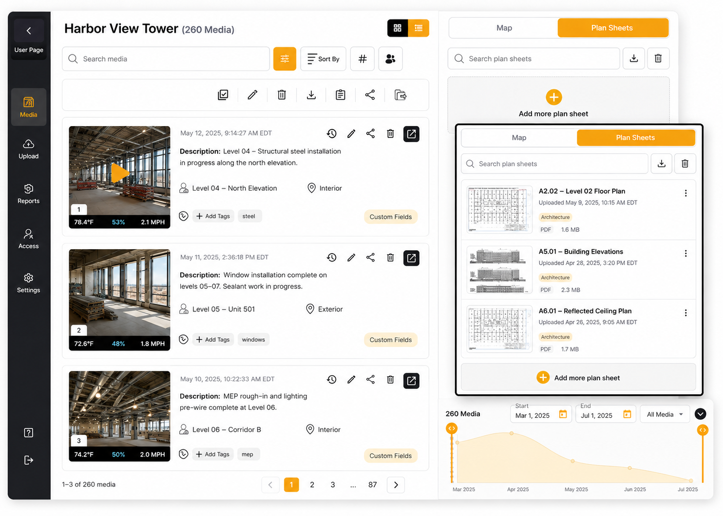
Search and review project records, manage media in map and plan sheet context, inspect photo details and metadata, and create reports and deliverables.
Searchable Project Records
Find evidence through AI-assisted visual search, metadata, timelines, maps, plan sheets, project areas, and long-term project history.
Personalized Reporting & Deliverables
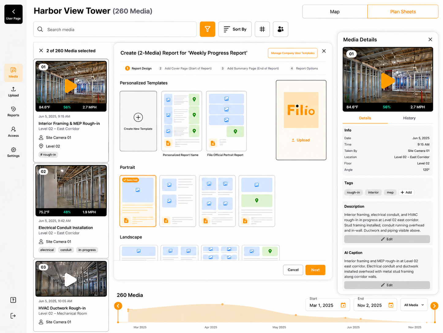
Build reusable reports from selected evidence, fields, maps, plan sheets, branded layouts, and supported PDF or Word outputs.
AI-Assisted Organization
Use project-specific guidance, editable captions, labels, summaries, and transcription to add consistent, reviewable context to supported records.
Maps, Plan Sheets & GIS Review
Review mapped project evidence, plan sheet context, directional markers, defined areas, and supported custom map or GIS layers.
CONNECTED WORKFLOW
One Connected Field Documentation Workflow
The mobile app and web app work as one system.
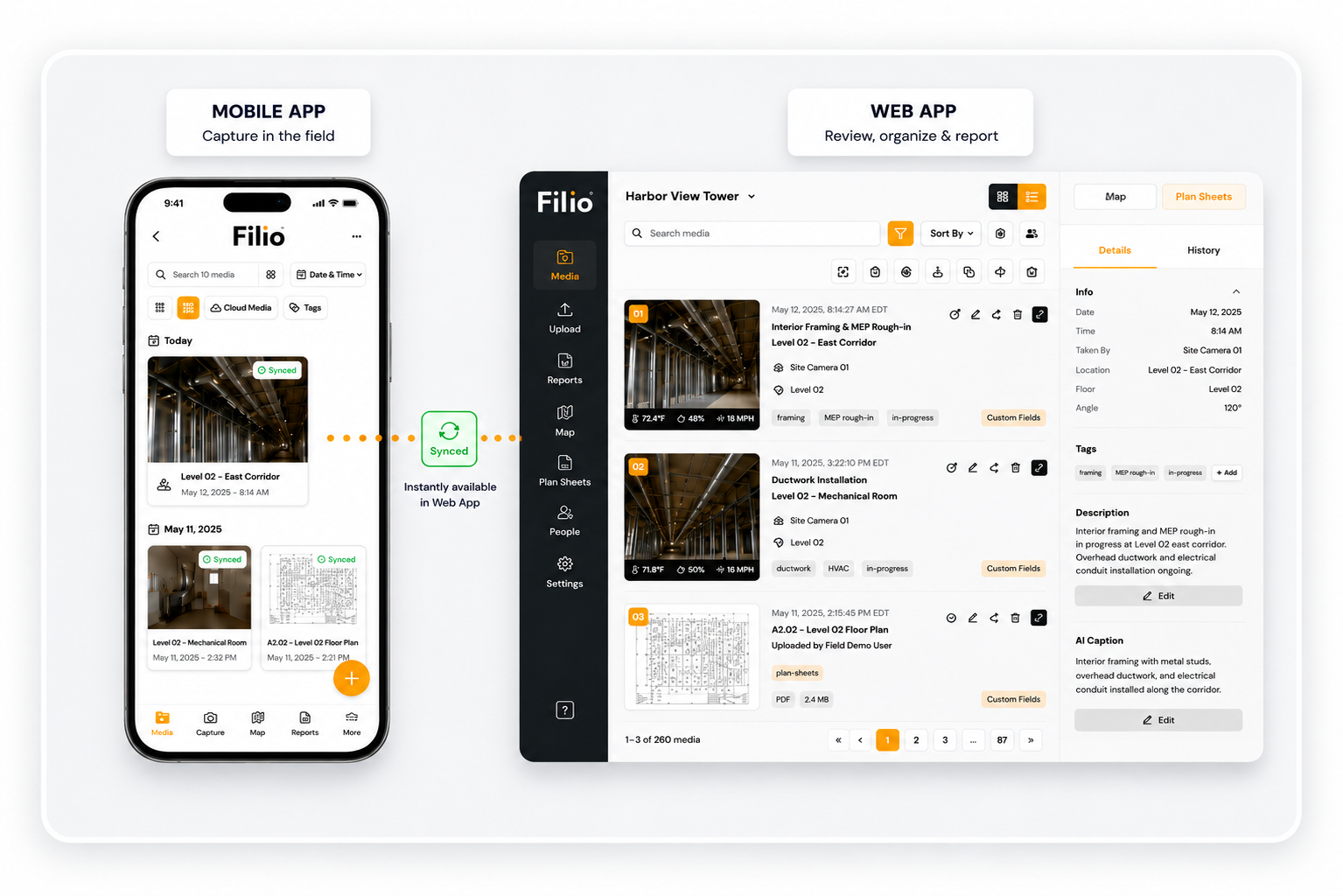
Capture Site Conditions
Photos, video, 360° media, documents, Interior Scan, before-and-after records, voice, annotations, and supported measurements.
Locate & Contextualize
Maps, plan sheets, Walking Placement, directional markers, time, GPS, weather, users, tags, and fields.
Compare & Organize
Preserve earlier/later conditions and add reviewable AI-assisted captions, labels, metadata, and structured project context.
Find the Evidence
Retrieve records through AI-assisted search, filters, timelines, maps, plan sheets, areas, and project history.
Report, Share & Preserve
Turn selected evidence into personalized deliverables, share with authorized stakeholders, and keep the searchable project record available for later review.
AI AND AUTOMATION
AI and Automation
AI-assisted tools add reviewable structure to project records and reduce repetitive documentation work.

Project-Specific AI Guidance
Set project-level instructions so supported AI output follows the project’s terminology and documentation priorities.
AI Captions & Labels
Generate editable descriptions and visual labels that add reviewable, searchable context to supported project records.
AI Labels & Structured Context
Combine AI-generated visual labels with project tags and custom fields to organize supported media consistently.
Multilingual Voice-to-Text
Turn spoken field observations in supported languages into editable text connected to the project record.
Video Transcription
Convert speech in supported project videos into reviewable text for search and documentation.
MAPS AND PLAN SHEETS
Maps and Plan Sheets
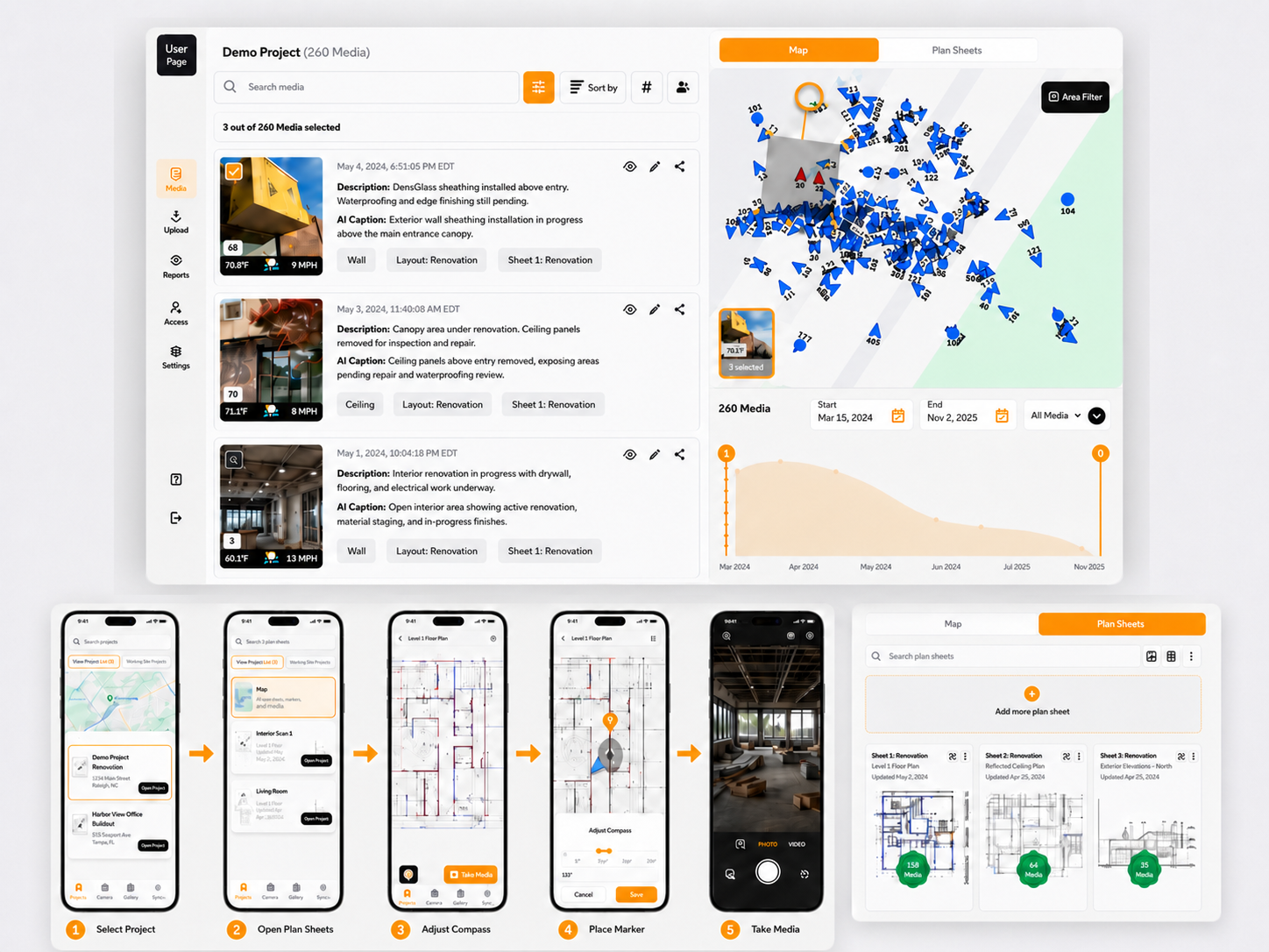
Keep visual evidence connected to where work happened, on the project map, drawing, plan sheet, or defined area.
Map-Based Media Capture
Capture supported media directly from a project map so the record begins with geographic context.
Plan Sheet Media Capture
Capture from a selected plan sheet so records remain connected to the relevant drawing and area.
Walking Placement on Plan Sheets
Create plan-linked, directional photos as you move through a space after the supported setup path.
Directional Markers & Correction
Review marker position and viewing direction; use supported controls such as Fix Marker, Move Marker, and Set Direction.
Plan Sheet Management & Map Overlay
Upload and manage supported plan sheets and position them within the project map context.
Project Maps & Base Map Views
Review project records against supported standard, satellite, terrain, or other enabled map views.
Custom Map / GIS Layers & Defined Areas
Add supported project-specific layers and areas for boundaries, routes, assets, environmental context, or location-based review.
Move Media Between Layouts
Correct the map or plan sheet relationship of selected project records without rebuilding the media record.
FIELD CAPTURE
Field Capture
Create visual records in the field and keep them connected to the active Filio project.
Showing Photo Capture, slide 1 of 3.

Photo Capture

Timer Capture

Video Capture
Photo & Multi-Photo Capture
Capture individual photos or efficient photo sequences within the selected project context.
Timer Capture
Use timed photography for hands-free, staged, or repeatable field images.
Video Capture
Record walkthroughs, conditions, progress, and spoken observations within the project workflow.
360° Photo & Video Capture
Create supported immersive 360° records using compatible capture workflows and camera connections.
Interior Scan — 2D/3D Space Capture
Capture an indoor space with on-screen guidance, review the generated result in 2D or 3D, and connect it to a plan sheet destination.
Before & After
Use an earlier photo as reference, capture a later condition with on-screen guidance, and review the two records interactively.
Document Scan & Existing Media Import
Bring paper records or supported existing device media into the correct Filio project.
Offline Field Capture
Continue supported capture with limited connectivity and synchronize eligible records when a usable connection returns.
Metadata and Traceability

Automatic Field Context

Edit Location Metadata


Tags & Custom Fields

Version History
SEARCH AND RETRIEVAL
Search and Retrieval
Find project evidence by content, context, time, location, and project structure, not only by file name or folder.
Showing Search Results, slide 1 of 4.

Search Results

Search Filters

Map & Timeline

Plan Sheet Search
AI-Assisted Visual Search
Search supported visual records using natural descriptions, reviewed AI captions and labels, metadata, and project context.
Metadata Search & Filtering
Narrow large libraries using dates, users, tags, fields, media types, locations, and other structured context.
Timeline Search
Navigate project records chronologically to review progress, prior conditions, and repeated documentation.
Map-Based Search
Retrieve evidence from its geographic position and project map context.
Plan Sheet Search
Find records from the drawing or plan sheet where they were captured or placed.
Area / Geofence Retrieval
Filter evidence by supported defined project areas or geographic zones.
Project Search & Long-Term Retrieval
Search across authorized projects and return to historical records for closeout, maintenance, claims, inspections, or future review.
REPORTS AND DELIVERABLES
Reports and Deliverables
Turn selected, contextualized evidence into reusable professional project records and deliverables.

Personalized Report Templates
Create reusable portrait or landscape report structures for recurring documentation workflows.
Report Builder & Editor
Build and revise reports from selected evidence without rebuilding the project history in a separate tool.
Media Blocks & Automated Fields
Combine selected media with available project, report, and media fields inside supported layouts.
Maps, Plan Sheets & Directional Context in Reports
Add supported spatial context so recipients can see where evidence belongs as well as what it shows.
Cover, Summary, Branding & Page Controls
Organize report presentation with supported cover/summary content, branding, page order, and layout settings.
Comments & Review
Use supported comments and review steps to clarify or revise report content before delivery.
Report History
Return to available report history and saved states to understand how a deliverable changed over time.
PDF / Word Export & Sharing
Export supported reports to PDF or Word and share authorized deliverables through available workflows.
ANNOTATIONS AND MEASUREMENTS
Annotations and Measurements
Add visual explanation and supported measurements directly to field evidence and downstream reports.

Annotations & Markup

Measurements in Reports
Photo Annotations & Visual Markup
Add supported drawings, arrows, shapes, text, and other markup to project visuals.
AR-Assisted & Object Measurements
Use compatible field measurement tools to add practical dimensions or scale to supported records.
LiDAR & Stereo-Depth Measurements
Use supported depth-based measurement workflows on compatible devices.
Measured Visuals in Reports
Include supported annotated or measured visuals in report layouts.
Collaboration and Permissions

Import Users


PROJECT ORGANIZATION AND CLOUD SYNC
Project Organization and Cloud Sync
Keep field and office work connected through project structure, synchronization, imports, downloads, and administration.


Project Portfolio


Company, Office & Group Structure
Organize users and projects around the company’s operational structure.
Users & Team Administration
Manage supported company users, roles, and project access.
Project Creation & Templates
Set up projects with reusable structures, maps, plan sheets, fields, permissions, and other available settings.
Project Status & Portfolio Organization
Organize active, completed, archived, or otherwise categorized work across the portfolio.
Project Selection & Field Access
Access assigned projects and the synchronized context available for field work.
Move Media Between Projects
Correct the project assignment of selected records without downloading and re-uploading them.
Connected Imports & Downloads
Bring in supported existing media and export eligible project media or structured data through available workflows.
Background Sync & Local Storage
Synchronize supported records when connectivity is available and manage eligible local device storage afterward.
Connected Mobile / Web Access & Branding
Use one shared project record across the mobile and web experiences, with supported organization branding where enabled.
SECURITY AND DATA GOVERNANCE
Security and Data Governance
Use available account controls and review Filio’s current security and data-practice documentation.


MFA & Authentication


Two-Factor Authentication
Use available two-factor authentication to add an additional account-verification step.
Account Protection
Use supported account-security and credential controls for authorized access.
Cloud Infrastructure & Safeguards
Store and synchronize project records through Filio’s cloud-based platform.
Data Retention & Deletion Practices
Manage archiving, deletion, restoration, export, and retention according to current product behavior and documented policies.
Documented Data Access Practices
Use current Filio legal and security documentation to understand authorized access and governance responsibilities.
Frequently Asked Questions
Answers about Filio’s field documentation software, connected apps, capture tools, reporting, collaboration, and project controls.
Field documentation software helps site-based teams capture, organize, search, report, and share records created during fieldwork. Filio connects photos, videos, 360° visuals, notes, maps, plan sheets, metadata, and reports in one project workflow.

Turn Field Visuals Into Searchable Project Records
Capture site conditions once, preserve their visual and spatial context, find the right evidence later, and turn selected records into professional deliverables without rebuilding project history from scattered files.